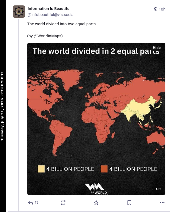
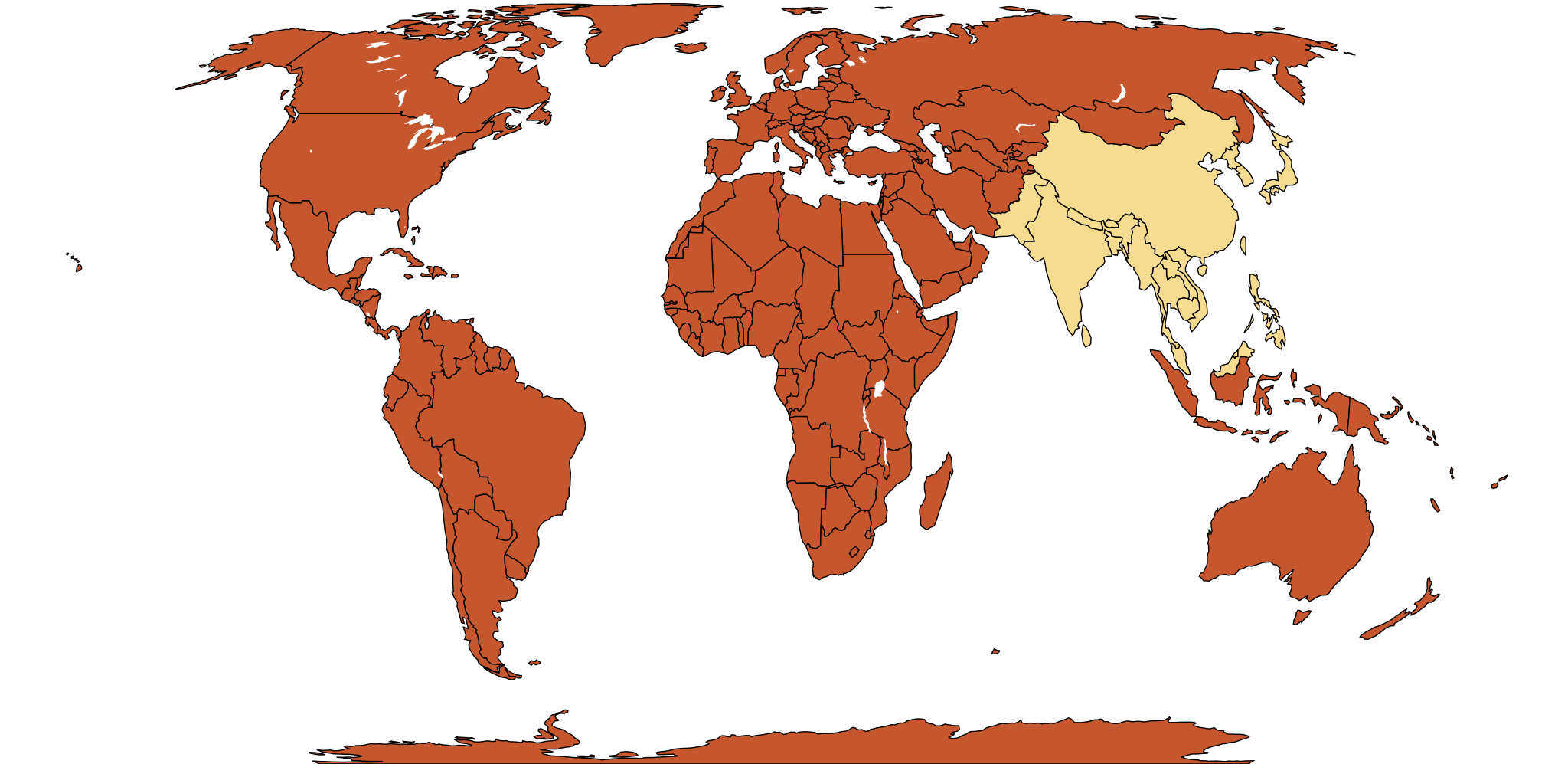
<p>A recent <a href="https://mastodon.online/@infobeautiful@vis.social/116959013106803416">posting</a> on Mastodon showed a map dividing the world’s population into two parts geographically. The map uses the <a href="https://en.wikipedia.org/wiki/Mercator_projection">Mercator projection</a>. My wife wondered what the same population division would look like using the <a href="https://en.wikipedia.org/wiki/Equal_Earth_projection">Equal Earth</a> projection. I did not know about “Equal Earth” and thus learned about it. To fulfill my wife’s every wish, I, ever the romantic, undertook to build an Equal Earth map.</p>
<img class=" wp-image-1114" src="https://salemdata.net/johnpress/wp-content/uploads/2026/07/20260721_203849_Tue.png" alt="" width="495" height="612" /> Original Mastodon map dividing the world population into two approximately equal groups
<p>I downloaded an SVG <a href="https://commons.wikimedia.org/wiki/File%3ABlank_world_map_Equal_Earth_projection.svg">map</a> using Equal Earth projections from Wikimedia Commons and I obtained the ISO country codes and population from <a href="https://download.geonames.org/export/dump/countryInfo.txt">geonames.org</a>. These figures are drawn from the population values contained in the GeoNames countryInfo.txt dataset downloaded on July 21, 2026; the underlying estimates may originate from earlier years. I isolated the data I’m interested in with:</p>
<pre>awk -F '\t' '
BEGIN {
OFS=","
print "iso2","country","population"
}
!/^#/ {
gsub(/"/, "\"\"", $5)
print $1, "\"" $5 "\"", $8
}
' countryInfo.txt > country_population.csv</pre>
<p> </p>
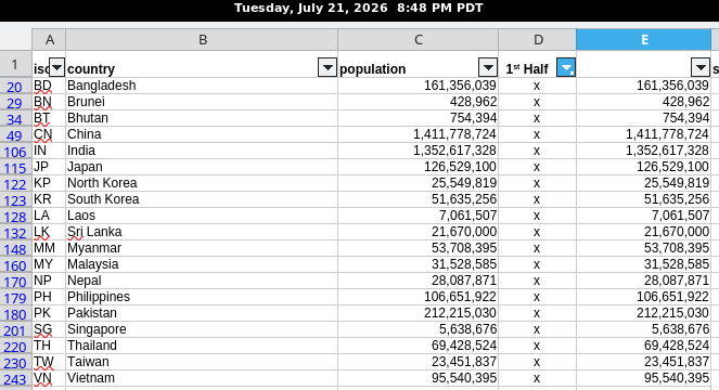
<p>I then identified the countries depicted in yellow in the original map and calculated their combined population in a spreadsheet. and calculated their population on my <a href="https://salemdata.net/johnpress/wp-content/uploads/2026/07/country_population.ods">spreadsheet</a>. The total world population is 7,624,210,908. These countries constitute 3,785,632,364 which is 49.65%.</p>
<img class="size-full wp-image-1115" src="https://salemdata.net/johnpress/wp-content/uploads/2026/07/20260721_204759_Tue.png" alt="" width="663" height="360" /> Countries shown in yellow and their reported populations
<p>I then inserted the country codes into the CSS to colorize the group yellow:</p>
<pre><span style="color: #00cd00;"><b>jlpoole@jp</b></span><span style="color: #9d9df7;"><b> ~/work/maps $</b></span> head -n 25 equal_earth_population_50_Percent.svg
<?xml version="1.0" encoding="UTF-8" standalone="no"?>
<svg xmlns="http://www.w3.org/2000/svg" width="2048.00" height="996.796" viewBox="-180.000 -87.6091 360.000 175.218" version="1.1">
<title>Blank world map (de facto country borders)</title>
<desc>
A map of the world, showing all countries' de facto borders in 2022, with major lakes overlaid. Border data is taken from <a href="http://www.naturalearthdata.com/">Natural Earth</a>. Equal Earth projection.
</desc>
<style type="text/css">
/* countries that have not been styled otherwise are gray */
.BD, .BT, .BN, .KH, .CN, .IN, .JP, .LA, .MY, .MM,
.NP, .KP, .PK, .PH, .SG, .KR, .LK, .TW, .TH, .VN {
fill: #F7DB91;
}
.country {
fill: #C6562E;
stroke: #000000;
stroke-width: 0.25px;
}
/* small-country circles are hidden by default */
circle {
<span style="color: #00cd00;"><b>jlpoole@jp</b></span><span style="color: #9d9df7;"><b> ~/work/maps $</b></span>
</pre>
<p>And, <em>voilà</em> :</p>
<a href="https://salemdata.net/johnpress/wp-content/uploads/2026/07/equal_earth_population_50_Percent.svg"><img class=" wp-image-1116" role="img" src="https://salemdata.net/johnpress/wp-content/uploads/2026/07/equal_earth_population_50_Percent.svg" alt="" width="543" height="264" /></a> 50% of World Population
<p> </p>
A recent posting on Mastodon showed a map dividing the world’s population into two parts geographically. The map uses the Mercator projection. My wife wondered what the same population division would look like using the Equal Earth projection. I did not know about “Equal Earth” and thus learned about it. To fulfill my wife’s every wish, I, ever the romantic, undertook to build an Equal Earth map.
Original Mastodon map dividing the world population into two approximately equal groups
I downloaded an SVG map using Equal Earth projections from Wikimedia Commons and I obtained the ISO country codes and population from geonames.org. These figures are drawn from the population values contained in the GeoNames countryInfo.txt dataset downloaded on July 21, 2026; the underlying estimates may originate from earlier years. I isolated the data I’m interested in with:
I then identified the countries depicted in yellow in the original map and calculated their combined population in a spreadsheet. and calculated their population on my spreadsheet. The total world population is 7,624,210,908. These countries constitute 3,785,632,364 which is 49.65%.
Countries shown in yellow and their reported populations
I then inserted the country codes into the CSS to colorize the group yellow:
jlpoole@jp ~/work/maps $ head -n 25 equal_earth_population_50_Percent.svg
<?xml version="1.0" encoding="UTF-8" standalone="no"?>
<svg xmlns="http://www.w3.org/2000/svg" width="2048.00" height="996.796" viewBox="-180.000 -87.6091 360.000 175.218" version="1.1">
	<title>Blank world map (de facto country borders)</title>
	<desc>
		A map of the world, showing all countries' de facto borders in 2022, with major lakes overlaid. Border data is taken from <a href="http://www.naturalearthdata.com/">Natural Earth</a>. Equal Earth projection.
	</desc>
	<style type="text/css">
		/* countries that have not been styled otherwise are gray */


.BD, .BT, .BN, .KH, .CN, .IN, .JP, .LA, .MY, .MM,
.NP, .KP, .PK, .PH, .SG, .KR, .LK, .TW, .TH, .VN {
    fill: #F7DB91;
}

.country {
    fill: #C6562E;
    stroke: #000000;
    stroke-width: 0.25px;
}


		/* small-country circles are hidden by default */
		circle {
jlpoole@jp ~/work/maps $

Leave a Reply